Indoor navigation needs indoor positioning
Indoor maps available on mobile phones are becoming essential for any large building or event. But without an indoor positioning system, the user experience just doesn’t match Google and Apple maps outdoors.

All large buildings need indoor navigation
Critical appointments
In hospitals, lost people lead to real inefficiency as well as anxiety. Hospitals could save up to $1 million per building by improving wayfinding.
Product location
Retailers are experiencing a 3-5% loss in revenue relating to unlocatable products. Help shoppers navigate your offer using indoor maps and indoor positioning.
Enhanced discovery
Exhibitions can deliver 20% more value to visitors and exhibitors by improving wayfinding and discovery, so that visitors are able to find all the exhibitors they're looking for.
Airport wayfinding
Up to 80% of delayed flights are due to passengers boarding late or not at all. And late flights cost the US economy $33 billion annually.
Our mapping integrations
Our 'blue dot' technology means an indoor map opens at the user's location, follows them while they navigate, and reroutes them when they take a wrong turn. Just like Google and Apple maps. We integrate with all the leading indoor mapping providers.
Indoor positioning has always been hard
Apple IMDF Fingerprinting
Apple IMDF Fingerprinting is free. But it isn’t accurate enough, and leaves out Android users.
WiFi solutions
Cisco Spaces positioning isn’t cost effective once the Spaces licence is taken into account, and the accuracy and latency aren’t sufficient for good navigation.
Our next generation solution
Self-calibration
We use advances in smartphone hardware, machine learning and cloud computing to achieve the best accuracy, but without the calibration and fingerprinting. Every single phone auto-calibrates to ensure optimal accuracy, all the time.
Works in any building
No requirement for specific access points, or specific beacon locations, works in any building.
Works with any iBeacon
Our own smart beacons have many advantages. But our indoor positioning works with any iBeacon compatible hardware.
Works with WiFi access points
Modern access points have Bluetooth Low Energy radios that can be configured to transmit iBeacon signals. Which means they can be used as the infrastructure for our indoor positioing solution. No additional overlay required.
Simple to integrate SDK
One single platform that not only provides navigation, but also includes location analytics and customer experience tools.
Easiest installation process
Self-install option is quick and simple. Or our global network of partners can do the installation for you. Either way, we have the quickest and simplest installation process in the market.
Millions of users across the globe
Our positioning software has been downloaded by tens of millions of phones. Our solution is used by leading mapping providers, systems integrators, well know buildings, and event organisers across the globe.
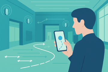
How indoor wayfinding works
Indoor wayfinding turns any building into a navigable space by combining three elements: a network of low-cost Bluetooth beacons that act as reference points, an indoor positioning engine running on the visitor’s smartphone, and a digital map rendered inside your existing app.
When a visitor opens the app, the positioning engine picks up signals from nearby beacons, combines them with inertial sensor data from the phone, and calculates their location - typically to within two to three metres. That position appears as a blue dot on the indoor map, just like outdoor navigation. The system then provides turn-by-turn directions to their destination, rerouting automatically if they take a wrong turn.
Unlike fingerprinting-based systems, Crowd Connected’s wayfinding solution requires no calibration walks and no manual signal mapping. Our patented self-calibrating algorithm adjusts to each building automatically, which means deployment takes hours rather than weeks. The beacons are battery-powered and wireless, so there’s no power or cabling to worry about - making it equally practical for permanent installations in hospitals and universities, or temporary deployments at events and exhibitions.
Indoor wayfinding that works like outdoor maps
Visitors expect indoor navigation to feel as natural as Google Maps. Our positioning technology delivers that experience - accurate blue-dot wayfinding across entire buildings, with the simplest deployment in the market.
Frequently asked questions
How does indoor wayfinding work?
Does indoor wayfinding work on both iPhone and Android?
How long does it take to set up wayfinding in a building?
What's the difference between wayfinding and indoor positioning?


Get updates and insights from Crowd Connected
Thank You
Thank you for submitting your details. You're signed up to our newsletter!
Sorry
There was a problem submitting this form. Please check your entries, ensure you're online, and try again.