RTLS and Asset Tracking
Lower cost and quicker to deploy than any other RTLS solution

Existing RTLS solutions are too hard to buy, install and integrate
Our next generation solution changes all that

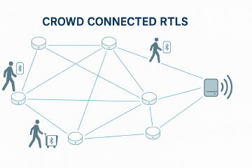
Tiny, battery powered wire-free devices. No power. No ethernet.
They connect to each other to form a network, sending data to the cloud via just one gateway per building.
A single low cost overlay in your building enables asset tracking, people tracking and indoor navigation.
Tracking tags are off-the-shelf Bluetoooth Low Energy devices. Allowing the widest possible variety of form factors, at the lowest possible cost.


Ground-breaking price performance
90% cheaper than RFID
Because we don't need expensive wired sensors in every room.
90% cheaper than Cisco Spaces
Because we avoid the excessive license costs charged by the networking giants.
65% cheaper than Bluetooth Gateways
Because our battery powered sensors are so much cheaper and easier to install.
85% cheaper than Angle of Arrival
Because we avoid the expensive and complex AoA sensor installation
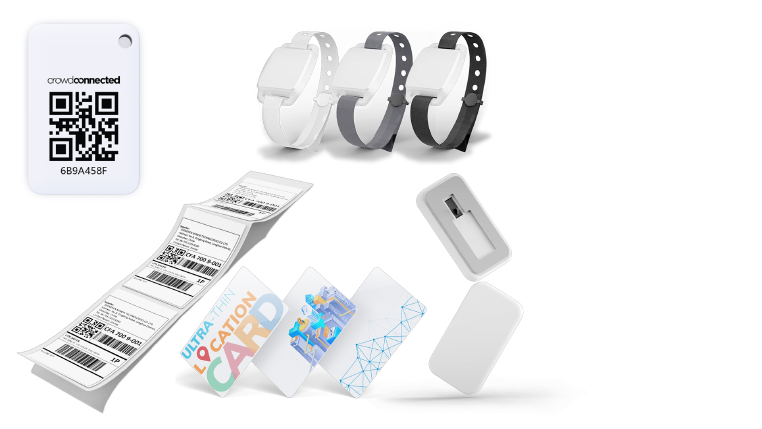
Qualified tracking tags
Crowd Connected provides a standard tag for both asset and personnel tracking.
But the open Bluetooth LE compatibility means we’ve already qualified a wide range of form factors from partner manufacturers.
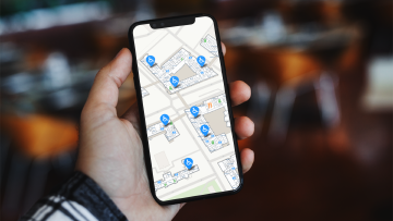
Fully featured web and mobile apps help deliver value on day one
Our web console and mobile app deliver value on day one, without requiring any integrations
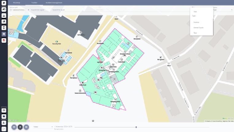
Search for a specific asset
- Clicking on the asset on the map will bring up additional information that has been configured for the asset.
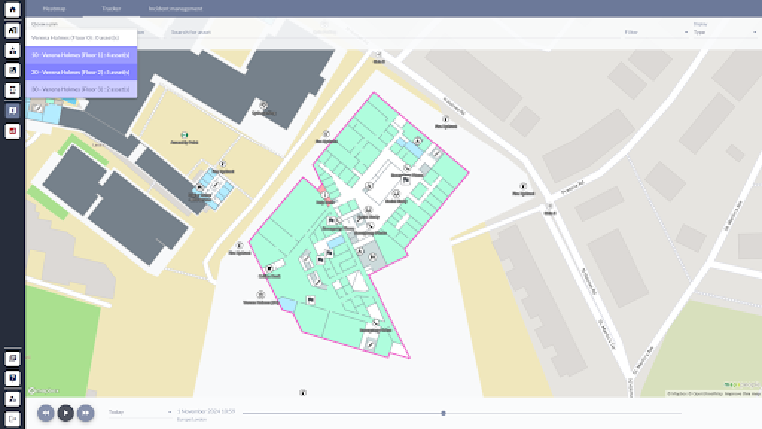
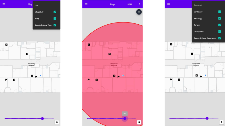
Filter by asset type
- Filter by asset type or department to see the locations of all wheelchairs or IV pumps.
Our ‘Find my nearest’ mobile app allows you to find nearby assets, and navigate to them.
- Combines blue dot with RTLS to provide an optimised ‘Find my nearest’ solution.
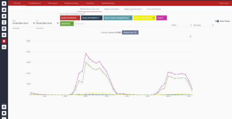
Charts for max, min and average levels
- The charting available in the console shows how the number of assets in a location changes over time, allowing you to see the maximum, minimum and average levels.
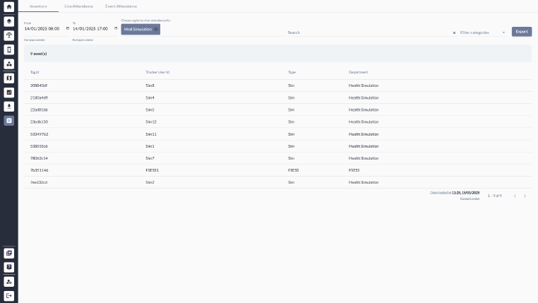
Reports to track stock levels
- The Inventory feature allows you to list all the assets at a location in a given time window, along with a total count.
How indoor asset tracking works
Asset tracking uses a combination of small Bluetooth Low Energy (BLE) tags attached to equipment and a network of battery-powered beacons installed throughout a building. Each tag broadcasts a signal that’s picked up by surrounding beacons, which relay the data through a wireless mesh network to a central gateway, and from there to the Crowd Connected cloud platform.
The platform calculates the real-time position of every tagged asset and displays it on an indoor map, accessible via a web console or mobile app. Staff can search for specific items, filter by asset type or department, and navigate directly to an asset’s location using blue-dot wayfinding.
Traditional RTLS (real-time location systems) typically require expensive wired infrastructure - power-over-ethernet sensors, network cabling, and specialist installation. Our approach eliminates all of that. The beacons are battery-powered and self-adhesive, the mesh network requires no cabling, and a single gateway covers up to 25,000 m². This makes deployment days rather than months, and running costs a fraction of conventional alternatives.
Choosing between BLE mesh, UWB, and Wi-Fi for asset tracking
Three RTLS technologies dominate the market in 2026, each with different trade-offs.
Bluetooth mesh uses battery-powered beacons that form a self-organising mesh network. Strengths: whole-building coverage from a single gateway, no cabling, install in hours, compatible with any BLE tag. Accuracy is two to three metres - sufficient for room-level positioning, inventory counts, and search-and-locate workflows. Best for hospitals, universities, and any multi-building estate where deployment speed and total cost of ownership matter more than centimetre precision.
Ultra-wideband (UWB) uses wired anchors and proprietary tags to achieve sub-30 cm accuracy. Strengths: high precision, low latency, well-suited to manufacturing floors where exact tool location matters. Limitations: anchors need power and ethernet at each installation point, infrastructure cost is significantly higher, and deployment takes weeks. Best for industrial environments where centimetre accuracy is genuinely required.
Wi-Fi RTLS leverages existing wireless access points to estimate tag position from signal strength. Strengths: uses infrastructure you may already have. Limitations: accuracy is typically five to eight metres, capture rates have degraded since smartphone MAC randomisation, and Wi-Fi-only tracking misses areas without AP coverage. Best for organisations with dense existing Wi-Fi who only need rough zone-level data.
For most asset tracking applications - hospitals, universities, warehouses, multi-site estates - BLE mesh delivers the best balance of accuracy, coverage, and cost. For a fuller technical comparison, see our RTLS hardware comparison guide.
Frequently asked questions
How does RTLS asset tracking work?
What tags are compatible with the system?
How does the cost compare to traditional RTLS?
How much area does one gateway cover?
What's the difference between BLE, UWB, and Wi-Fi for asset tracking?
Is RTLS asset tracking suitable for hospitals?
Can the system work in manufacturing and warehouses?
How is RTLS asset tracking different from RFID?
Learn more about asset tracking technology